Here's a brief history of the highway system we know today so you understand how it came to be and can easily find your way out on the open road.
American Roads: From Carriage Paths to Interstate Highways
Once upon a time, Americans (well, everyone) traveled on foot, horseback, or carriage on dusty or muddy roads, whose conditions varied greatly depending on the weather. At the turn of the 20th century, the "horseless carriage" was invented and became a popular way for the wealthy to travel. After the introduction of the economical Ford Model T in 1908, average families started being able to afford the luxury of a car, and the number of cars on the roads began to increase. With more cars on the road than ever before, roads needed to be better maintained. In 1916, President Wilson signed the Federal Aid Road Act. Development of roads had previously rested with each individual state or by trail associations, and many were in very poor shape - especially in rural areas, where it was difficult to reach a town to send or receive mail, access fresh water, or buy and sell goods. This act allowed for the federal government to oversee and pay for a portion of projects planned and completed by state-run highway departments.
 |
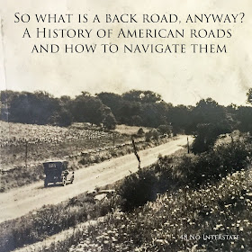
| I found this old photo of a scenic early 1900s dirt road at an antique shop in Waco, Texas |
Another Federal Aid Road Act followed in 1921, but roads were still a mess. The Joint Board of Interstate Highways was formed in 1925 after it became apparent that the existing confusion of roads needed to be transformed into a system of interstate highways. You may remember from middle school vocabulary that the prefix 'inter-' means 'between' or 'among'; therefore 'inter-state' highway refers to a road that travels between the states, allowing people and goods to travel more freely and does not refer to the Interstate Highway system that exists today. The most famous example of a road that was born as a result of the 1926 changes to the highway system is Route 66, which starts in Chicago, Illinois and ends in Los Angeles, California after passing through a total of eight states, maintaining the same identifying number throughout its nearly 2,500 miles.
 |
| 1926 Map of US Highways Image Source |
We're going to fast-forward 40 years and briefly talk about our present Interstate Highway system. By the 1950s, the number of cars on the road had multiplied tremendously and strained the existing highway system, making travel and trade between states more difficult. As a young Army officer in the early 1900s, President Eisenhower traveled across the United States on a military convoy and witnessed firsthand the sad state of the roads. During World War 2, he experienced the German Autobahn and wanted to create something like it in the US. He signed the Federal Aid Highway Act of 1956 to create better and more reliable roads for interstate commerce - 41,000 miles of limited-access Interstate Highways, to be exact. This Interstate Highway system changed the way Americans could travel, transport goods, and conduct business for the better, but they also bypassed small towns through which the previous highway system fed potential customers.
And there you have it: a (really) brief history of American highways in three paragraphs. If you're interested in more, check out the Sources at the end of this post.
All Over the Map
You'll get the most out of this post if you have a map of some sort to look at. I'd recommend pulling out your road atlas. If you're not familiar with such old-fashioned things, you can learn more about how to read a Road Atlas, from the meaning of different color roads to measuring distances without a GPS (you can also check the handy Key at the front of your Atlas for this information). If you don't have an atlas, then a maps app will work, too.
Have you ever wondered why different roads have different icons on them? If you're using an iPhone, highways are labeled with an icon identical to the sign you'll see on that particular road: Each state has a unique design for its state highways; US highways feature the familiar black-and-white shield, and Interstate highways are designated with the red-and-blue shield.
 |
| Note the difference between Michigan and Indiana's state road signs, the US highway shield, and the colorful Interstate shield. |
If you're using Google maps, roads are labeled with the black-and-white shield for US numbered highways, a black-and-white circle for state highways, and a blue-and-red shield icon just like the Interstate sign for the Interstate highway. Both of my atlases (atli?) are labeled like this, too.
So What is a Back Road, Anyway?
Our definition of a Back Road here at 48 No Interstate is any road that is not an Interstate. A Back Road passes THROUGH cities and towns, linking them together, instead of BY them. It allows drivers to be flexible with where they enter and exit the road instead of limiting them to the on/off ramp (also known as a controlled or limited access highway). A Back Road has stop signs, railroad crossings, and stoplights, and can be found in a variety of sizes, with speed limits varying from 20 to 75 mph. Anything from a quiet two-lane country road meandering through farmland to a route that has become so vital it has four lanes and a divider in the center is a Back Road in our book.
Back roads introduce road trippers to areas they otherwise wouldn't know about, or would zip right by on the Interstate. Traveling the back roads - and enjoying them - requires a little bit of a shift in your mindset; you have to be OK with taking a roundabout route to get from place to place. A back road may increase your travel time to three hours instead of just two, but you're less likely to come to a standstill as a result of an accident or construction, making it a more enjoyable three hours. The phrase 'the journey is the destination' sums it up quite nicely. The focus shifts from getting to a particular location to enjoying the process of traveling to that location.
Have you seen the Disney/Pixar movie Cars? It shows viewers the impact that the arrival of the Interstate Highway had on a fictional small town on Route 66. This clip perfectly sums up our thoughts on why back roads are so awesome!
The effect of the Interstate System was seen in towns across America after it was constructed in the 1950s - not just those on Route 66. These often sleepy old towns are the ones I love passing through most on a back roads road trip. Whether it's close to home or across the country; whether it's a run-down town that's seen better times or one that's seen a resurgence and oozes charm, these off-the-beaten path locations are wonderful places to stop for a stroll down main street, a great local meal, or to peruse a small shop. Across the country, many downtowns are growing into vibrant business districts with local shops and restaurants, apartments, and offices moving back into them, just waiting for you to visit.
I-95 runs more or less parallel to US 1 and diverts travelers away from great downtowns like Fredericksburg, VA (above) and Annapolis, MD (below).
It's a Numbers Game
You drive on them every day as you commute to and from work, the grocery store, or the kids' soccer practice. You might even live on one. But do you know how the roads got the numbers that are assigned to them?
On November 11, 1926, following two years of meetings to determine the best way to introduce consistency and clarity to our roads, the US numbered highway system was adopted.
Prior to the implementation of the numbered highway system, roads were known by names only: the Lincoln Highway, the Kings Highway, the Pacific Highway, the Old Spanish Trail, the Santa Fe Trail, the Dixie Highway, and more. Local trail associations would mark these highways by painting on barns, telephone poles, or any other structure that drivers would be able to see from the road.
To add to the confusion, directional signs varied from state to state prior to 1926. The new numbered highway system didn't just introduce consistent names to identify these roads; it also introduced clear and consistent signage to mark them. Not only did US highways get a new black-and-white shield logo for their signs, but other signs began to look like the ones we know today: octagonal stop signs, round railroad crossing signs, diamond-shaped warning signs, and more.
To help you orient yourself on numbered US highways,
East-West routes ending in '0' (with the exception of US 2 along the Canadian border) are transcontinental, or close to it. East-West route numbers begin with the lowest in the north - US 2 - and the highest in the south - US 90 - which covers the distance from Florida to California along the southernmost states.
The main North-South routes end in '1' and run mostly the full height of the country. US 1 is the Easternmost North-South route along the Atlantic states, and US 101 is the Westernmost, winding through California, Oregon, and Washington.
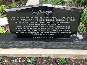 |
| A monument to the Lincoln Highway sits in downtown Valparaiso, Indiana. |
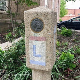 |
| The marker above is one of many that was placed along the route by Boy Scouts in 1928 (also in Valparaiso, IN). |
To add to the confusion, directional signs varied from state to state prior to 1926. The new numbered highway system didn't just introduce consistent names to identify these roads; it also introduced clear and consistent signage to mark them. Not only did US highways get a new black-and-white shield logo for their signs, but other signs began to look like the ones we know today: octagonal stop signs, round railroad crossing signs, diamond-shaped warning signs, and more.
 |
| Many roads are still marked with signs featuring these historic names, like this one on the Santa Fe Trail in Kansas |
To help you orient yourself on numbered US highways,
- Odd-numbered roads run North-South.
- Even-numbered roads run East-West.
And as a reminder, the sun rises in the East and sets in the West. If you mean to be traveling East to Memphis from Flagstaff and you find yourself driving into a sunset, you might want to pull over and check the map.
Now that you can tell what direction you're heading just by knowing what road you're on, let's talk a little more about those numbers. The main continuous routes that span large portions of the country typically consist of two digits: Route 66, US 50, and US 101 are a few that may ring a bell (Weird fact: US 101 is technically considered to be two digits, with the '10' being counted as a single digit).
 |
| We happened to travel on Route 66 in 2016, its 90th year! |
East-West routes ending in '0' (with the exception of US 2 along the Canadian border) are transcontinental, or close to it. East-West route numbers begin with the lowest in the north - US 2 - and the highest in the south - US 90 - which covers the distance from Florida to California along the southernmost states.
 |
| US 50 cuts across the middle of the country, terminating near Sacramento, CA |
The main North-South routes end in '1' and run mostly the full height of the country. US 1 is the Easternmost North-South route along the Atlantic states, and US 101 is the Westernmost, winding through California, Oregon, and Washington.
 |
| CA 1 ends in Northern California and US 101 continues along the coasts of Oregon and Washington |
You'll often find that one road might have two or three different numbers assigned to it; usually this is when a state or county road and a US highway intersect for some distance. Or, sometimes a US highway joins with an Interstate highway.
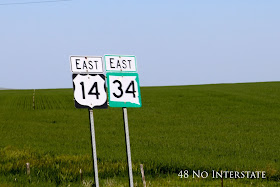 |
| US 14 and SD 34 merge for some time near Pierre, South Dakota |
The highway system continues to grow and change today, with new bypasses and interstate highways popping up in heavily traveled areas. Next time you plan a road trip, take to the back roads, see more of America, and enjoy the journey!
| 1947 Rand McNally US Road Map Image Source |
Now that you know how to navigate the American highway system without having to constantly pull out a map, you're all set for some scenic back roads travel!
 |
| US 60 near Magdalena, New Mexico |
Thanks for reading, and I hope you enjoyed learning about the development of our modern road system in the United States - and how to navigate it.
If you liked this article or found the information to be helpful, let us know!
We appreciate your comments, pins, shares, tweets, and likes!
Check out these groups for more travel inspiration!
If you liked this article or found the information to be helpful, let us know! We appreciate your comments, pins, shares, tweets, and likes!
SOURCES
If you're interested in reading many more paragraphs on this subject, check these sources. I personally found them fascinating, but they may not be for everyone.
Federal Highway Administration:
Federal Aid Road Act of 1916: Building the Foundation
Federal Aid Road Act of 1916: Creation of a Landmark
From Names to Numbers
US 1: Fort Kent, Maine to Key West, Florida
Wikipedia
Numbered Highways
AAA (American Automobile Association)
A Journey in Road Maps
Map Images
1915 road map
1947 road map



Interesting to learn more about what the signs and numbers mean. Since I have been spending more time in England I have been starting to learn about their system, which is pretty different! Thanks for sharing on #TheWeeklyPostcard
ReplyDeleteI would be interested to hear about that (and of course, spending time in England would be pretty awesome, too!); their highway system would have evolved from much older trails than ours did!
DeleteVery interesting and educational about the US highway numbering system. I knew a bit about the east/west and north/south numbering but I did not know how the first digit was determined.
ReplyDeleteThanks for stopping by, Rhonda!
DeleteOOh thanks for the history lesson! I knew most of that from school, but it was nice to learn more! Thanks for linking up with #TheWeeklyPostcard!
ReplyDelete(www.caliglobetrotter.com)
Glad you enjoyed it and got a little refresher. :-)
DeleteBack roads have character and personality! Great article, thanks for linking in to #wkendtravelinspiration!
ReplyDeleteWe couldn't agree more!
Deletewooow! great historic lesson!
ReplyDeleteFascinating. Thanks.
ReplyDeleteAnother lovely post! I'm really enjoying reading all about your amazing adventure! #theweeklypostcard
ReplyDeleteThank you, Hilary!
DeleteGreat information article on what a back road is in the USA. Thanks for sharing :-) #feetdotravel
ReplyDeleteIf I have the time, I much prefer taking the "back roads" over the interstate any day! I used to get so annoyed with my mom doing this when I was younger, so I guess I'm old now ;)
ReplyDelete#TheWeeklyPostcard
As a history teacher, I find information like this fascinating. Out country is so large, having a good transportation system is essential!
ReplyDeleteInteresting history! We had to giggle at the comment that roads were still a mess in 1921. Some things never change! ;) Thanks for sharing on #TheWeeklyPostcard!
ReplyDeleteCheck out ConnectSmart if you're sick of spending time stuck in traffic. This software will make sure you always have the optimal route planned with its features that prioritize smart connections. In order to ensure a smooth journey, it takes into consideration factors such as weather and road closures. It will get you where you're going more quickly and with less hassle than before, so I think you should give it a go.
ReplyDelete