Our name obviously comes from this crazy trip, appropriately named due to the fact that we visited the 48 continental states on a road trip where the interstate was avoided at all costs (confession: we did have to cheat a few times, but more on that next week!). This idea developed over time after our first back roads road trips to Florida and California and a few other much smaller no interstate trips over the years. We would say to each other, "Wouldn't it be awesome to do the whole country on back roads?" Eventually, the opportunity arose, and we took it.
The US is the third largest country in the world, covering 5.98 million square miles (9.63 million square kilometers). It's a unique experience to see the entire country (well, 24/25ths of its smaller units, which you may know as...states) in one 80-day trip.
On one hand, it's the best way to see it because you're seeing a chunk of each state in a short period of time and therefore develop a better mental map or idea of the different parts of that region than you did in your fifth grade social studies class. On the other hand, unless you have unlimited time and resources, there is a constant need to 'save it for next time' and move on to the next town, therefore not fully experiencing any individual place before leaving it.
Our route changed very little from the hastily sketched diagram you see above, though there were a few places where we were either forced or chose to take a different route. It reminds me of the convoluted routes Billy takes around the neighborhood in Family Circus, and in a way it was. Like Billy, we certainly didn't take the most direct route anywhere. Unlike Billy, we covered thousands of miles: approximately 22,000!
Here's a brief photo tour of those 22,000 miles.
As we looked across the bay toward Tampa under a stormy sky on the first full day of our road trip, what we were doing and where we were going still hadn't really sunk in.
Every corner in New Orleans all at once looks the same and different from the
others. Here, tourists and locals pass through Jackson Square just before sunset.
Dry riverbeds abound in Texas; watch out though, the low crossings at small dry creekbeds can easily flood.
This was not a Close Encounter of any kind but one of the many gas flares you see on the drive through oil-drilling areas like New Mexico.
Sitting at the top of Bell Rock near Sedona, Arizona to watch the sunset was a good decision until we had to walk back to the car in near darkness. Only one small cactus jumped out to attack me as we carefully made our way back to the parking lot.
When you think of California, the image that comes to mind is probably of wide sandy beaches, Hollywood Blvd., or the Golden Gate Bridge. This view down toward a ribbon of road looping its way through the mountains along the Pines to Palms highway between Palm Springs and Los Angeles was not one that we expected.
We hadn't planned to pass Mexican Hat but spotted it as we drove through the red rocks of the Navajo nation in Southeastern Utah.
During an early morning run on a mountain trail in Kanab, Utah near Bryce Canyon National Park, these four deer and a few noisy roosters down in the town seemed to be the only other creatures awake besides me. It was a peaceful, chilly morning with a stunning sunrise.
It's hard to fathom the size and expanse of Horseshoe Bend, even when you're standing there looking at it in person. To give you some perspective, find the tiny dot in the river above the second 'E' in 'interstate'. That's a paddle boat. With humans in it. And it's a barely distinguishable dot in the middle of a wide river looping around a massive rock formation. What's possibly more shocking is how close people go to the side of those cliffs (which have no fences or guardrails) to get a picture of their feet at the edge. The closest I went was about five feet away, and that felt about 10 feet too close for me!
Like Mexican Hat, Shiprock was another of those road trip surprises that comes out of the blue. It rises high above the otherwise flat terrain of the Navajo Nation in northwestern New Mexico, looking suspiciously like the Wizard's palace in Oz. Except it's not green, and there's no yellow brick anywhere around it.
Running out of gas on a road trip is no joke, but for us, the situation was about as ideal as it could have been. As we approached the outskirts of Lubbock, Texas, we had gotten so engrossed in the Autobiography of Benjamin Franklin audiobook that we hadn't heard the 'running out of gas' warning beep, and the car suddenly stopped working. Nick shifted into neutral, and we rolled on fumes to exactly 0.5 miles away from the closest gas station. Short of actually making it into the gas station parking lot, this was about the most ideal scenario for running out of gas we could think of.
Not the typical scene you think of when you think of our nation's capital city, is it? Everyone has seen a picture of the White House or Washington Monument, and this city scene seemed like a more appropriate representation of passing through the city on a road trip.
This little red 19th century one room schoolhouse in Maryland brightened up an otherwise wet and dreary day.
Behind the iron gates sits a marker from the Mason-Dixon line in present-day Delaware (at the time, the land was part of the Pennsylvania colony). First measured by local surveyors in about 1760 and marked by two small stones, a larger stone was put in place after Charles Mason and Jeremiah Dixon made their measurements in 1764 to solve a land dispute and establish the border between Maryland and Pennysylvania.
The cupola of Independence Hall peeks over the roof line of the Old City Hall building in the heart of Historic Philadelphia. Roaming through the cobblestone streets with no particular destination recalling as much of the history we learned in school as we could was a nice break from the road.
The view from our Brooklyn hotel (along with a larger room and more convenient parking) made the long subway rides into Manhattan worth it.
About 60 miles north of the city, the United States Military Academy at West Point boasts some amazing architecture including the protestant Cadet Chapel, nestled in the mountains overlooking the campus and Hudson River far below.
Quaint coastal scenes like this one in Rhode Island were common as we drove along US 1 between NYC and Maine.
Built in the 1600s, the home of Paul Revere is the oldest building in downtown Boston. In the 1800s, it became unrecognizeable as a result of renovations to turn it into a boardinghouse and later a variety of different shops. It was restored in the early 1900s to the condition it would have appeared when Paul made his famous ride in 1775 and has been open to tourists for over a hundred years!
It turned cold on us as we traveled US 1 through New England; for several days, it was as chilly and unpleasant (or maybe more so) as it looks in this photo. Though it felt pretty miserable, it made for a uniquely beautiful drive through these coastal towns along an angry ocean under a veil of fog.
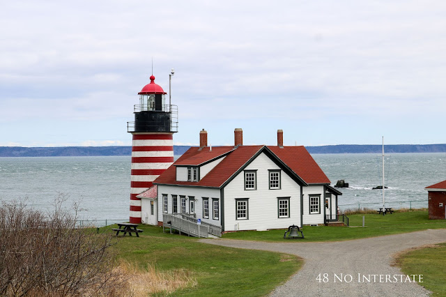
There's something about West Quoddy Head Light, the Easternmost lighthouse in the US, that I just love to look at. The red and white tower rising out of the green grass, set against the backdrop of blue-gray water is very appealing to my eyes. It was super cold and miserable in person, though.
We saw very few of the many covered bridges in Vermont, but this particular stretch near Northfield had three in a row, giving us a pretty big bang for our buck!
We crossed the border (the Canadian border guard definitely thought we were suspicious characters when we told him about our road trip in response to his questions about why we were coming to Canada and why we were driving so far from home; he seemed to think we were nuts for doing it!) for a quick international stop. Here, the American falls provide a dazzling backdrop for a garden full of stunning Canadian tulips.
Mackinac Island was another place I knew nothing about until we visited it. The absence of cars doesn't mean you can just walk down the middle of the street, though; carriages and bicycles replace them in large numbers, so stick to the sidewalk!
During our tour of Lambeau Field, I got separated from our group when I stepped into the restroom. As a result, I missed the part of the tour that takes visitors through the tunnel and on to the Packers' field. When I finally found the group again the tour was basically over, but the tour guide kindly took us on a private mini-tour of the field. We learned that the guide and his brother had gotten tickets in the kids' section behind one of the end zones in the 70s or 80s. When the section was later converted into a regular section, they managed to keep hold of them and still have the same tickets today.
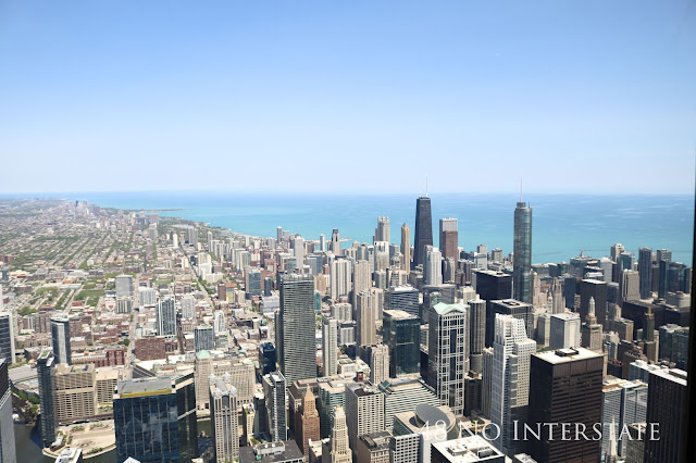
Illinois gets two pictures of very different scenes. The first is a city and lake view from the top of the Willis (or Sears, if old habits die as hard for you as they do for me) Tower...
...the second is a 1.4 mile section of brick road on Route 66 laid in 1931 in Auburn, IL, about 200 miles Southwest of Chicago.
Joplin sits on Route 66 in southwest Missouri. Completely by coincidence, we drove through Joplin on the fifth anniversary of the EF5 tornado that blew through on Sunday, May 22, 2011, taking with it the lives of 161 people and destroying areas up to a mile wide. It was surreal to drive through and pick out these areas, easily noticed as a result of sudden stretches of new construction or steps going from the sidewalk up to nowhere, on lots where houses had not been rebuilt. For the fifth anniversary, the town held a monthlong celebration, ending with a marathon and a remembrance ceremony the weekend we passed through.
Since they're so high up in the air, it's hard to grasp how large wind turbines actually are. Compare the size of a turbine blade lying on the ground to the telephone poles in the photo below, taken as we filled up the gas tank somewhere in western Kansas. Hundreds of blades just like this one were laid end to end at this massive facility.
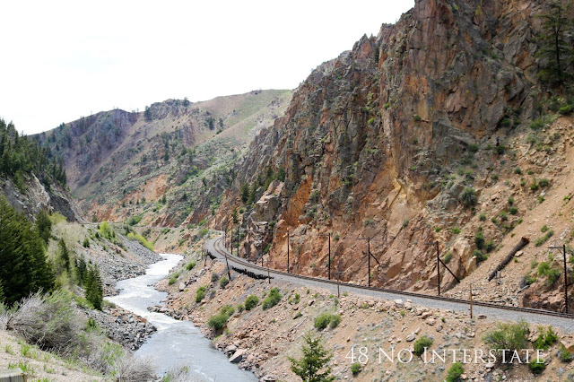
Along the Colorado River between Denver and Steamboat Springs, CO, US 40 parallels the tracks that carry Amtrak's California Zephyr from Chicago to San Francisco. What a way to see the country!
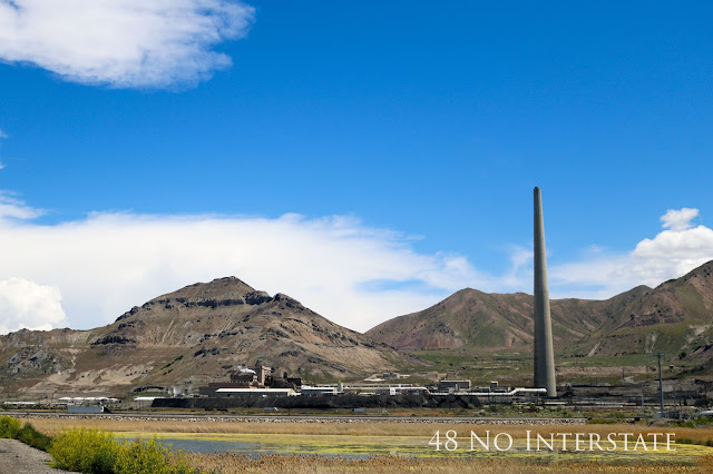
Nearly as tall as the Empire State Building (1,250 feet not counting its antenna), Utah's tallest man-made structure is the Garfield Smelter (1,215 feet) at the Rio Tinto mining facility, whose annual production includes tons of copper, thousands of ounces of gold, and millions of ounces of silver.
To reach the beach from our cliff-top hotel in Lincoln City, Oregon, we had to take 112 steps down - and back up. A short stroll on the chilly beach was the most time these east coasters have spent in such close proximity to the Pacific.
Evidence of Washington's cherry industry was present in the form of thousands of crates stacked up by the road as we drove through the northeastern corner of the state. When we came upon the Rest Awhile Country Market in Pateros, we pulled over for a really quick rest - and to buy some cherry pie for the road. It was amazing!
Passing through the panhandle of Idaho (is it still a panhandle if it runs vertically?) meant we were barely in the state, but this sunset near Sandpoint over the Pend Orielle River and the mountains of the Kanisku National Forest was a beauty.
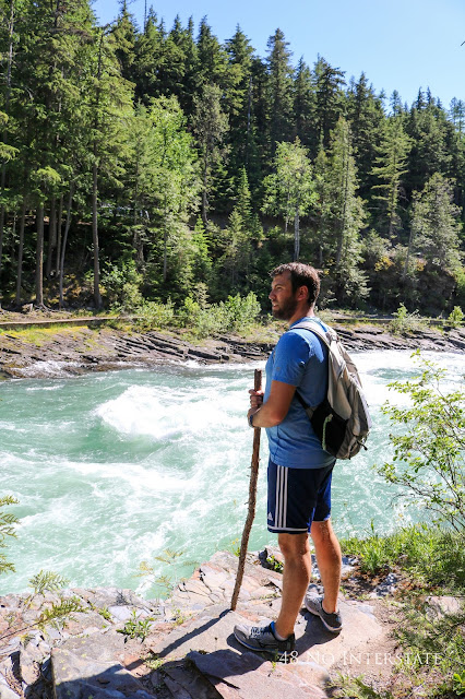
Montana was one of those states that made it incredibly difficult to pick just one picture for this post. This one from our hike along the river in Glacier National Park was the winner.
Prior to the two days we spent in Yellowstone, I knew nothing about it other than the presence of Old Faithful and the fact that it was the first national park. There were hundreds of pictures of geysers, colorful springs, and wildlife to choose from, but I kept coming back to this one of the beginning of the sunset over a green valley as we left the park to head east across Wyoming.
While I don't think I want to visit Minneapolis between October and April because I don't think I could handle the cold, it was beautiful and pleasant for an early June trip. Before leaving town, we took a walk along a short stretch of the Chain of Lakes and wished we had time to rent a kayak, too.
We're reinforcing the stereotype of Iowa as being full of farms and cornfields, but I'm a sucker for sunsets and flat stretches of farmland and couldn't resist.
Little did we know that when I walked into an alleyway in Noblesville, Indiana to get a picture of its amazing city hall building that nearly a year later, we would be back in that same town for an extended period for Nick's work eating dinner al fresco at an Italian restaurant in that exact alley.
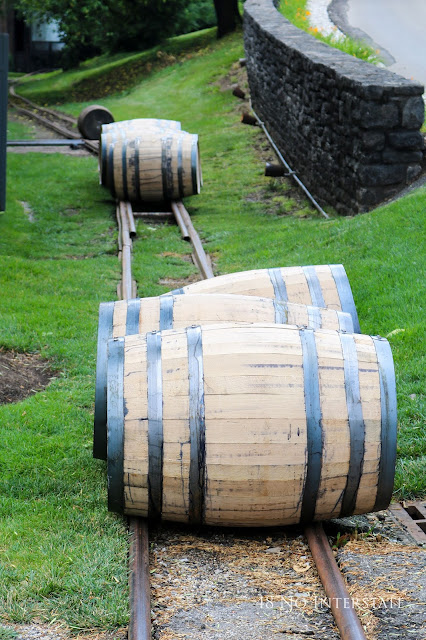
Driving through the lush, green horse country near Lexington, we made one stop on the Kentucky Bourbon Trail at Woodford Reserve. The tour was fantastic, but it didn't make me like bourbon any better.
We accomplished our task in West Virginia, state number 48! The only thing we did there was get out of the car to document said accomplishment with a selfie, though.
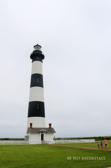
We finished off our trip with a weekend in the Outer Banks, but even though it was mid-June, it was NOT pleasant beach weather! We arrived at the Bodie Island Light Station too late in the day to get tickets for the self-guided climb so enjoyed a scenic walk around its grounds instead.
We returned home to South Carolina with a lifetime full of experiences and a long list of places we'd like to visit again slower and more intentionally. It felt strange to walk into our house, and after three months of not cooking, it took me a week or so to get back into the swing of things. It was a fun and amazing experience, and even though we missed a few items on the list of places we wanted to stop, we're so grateful we were able to take the trip and wouldn't change a thing!
Thanks for following along with us on this trip down memory lane. Check out the next post in this series with answers to commonly asked questions about taking an extended back roads road trip!
On one hand, it's the best way to see it because you're seeing a chunk of each state in a short period of time and therefore develop a better mental map or idea of the different parts of that region than you did in your fifth grade social studies class. On the other hand, unless you have unlimited time and resources, there is a constant need to 'save it for next time' and move on to the next town, therefore not fully experiencing any individual place before leaving it.
Our route changed very little from the hastily sketched diagram you see above, though there were a few places where we were either forced or chose to take a different route. It reminds me of the convoluted routes Billy takes around the neighborhood in Family Circus, and in a way it was. Like Billy, we certainly didn't take the most direct route anywhere. Unlike Billy, we covered thousands of miles: approximately 22,000!
Here's a brief photo tour of those 22,000 miles.
As we looked across the bay toward Tampa under a stormy sky on the first full day of our road trip, what we were doing and where we were going still hadn't really sunk in.
Every corner in New Orleans all at once looks the same and different from the
others. Here, tourists and locals pass through Jackson Square just before sunset.
San Antonio's Riverwalk is a lively and colorful place to spend the day shopping, eating, walking beside and climbing bridges to cross the canal, or taking in the bright colors and activity from a water taxi.
Dry riverbeds abound in Texas; watch out though, the low crossings at small dry creekbeds can easily flood.
This was not a Close Encounter of any kind but one of the many gas flares you see on the drive through oil-drilling areas like New Mexico.
Sitting at the top of Bell Rock near Sedona, Arizona to watch the sunset was a good decision until we had to walk back to the car in near darkness. Only one small cactus jumped out to attack me as we carefully made our way back to the parking lot.
When you think of California, the image that comes to mind is probably of wide sandy beaches, Hollywood Blvd., or the Golden Gate Bridge. This view down toward a ribbon of road looping its way through the mountains along the Pines to Palms highway between Palm Springs and Los Angeles was not one that we expected.
We hadn't planned to pass Mexican Hat but spotted it as we drove through the red rocks of the Navajo nation in Southeastern Utah.
During an early morning run on a mountain trail in Kanab, Utah near Bryce Canyon National Park, these four deer and a few noisy roosters down in the town seemed to be the only other creatures awake besides me. It was a peaceful, chilly morning with a stunning sunrise.
It's hard to fathom the size and expanse of Horseshoe Bend, even when you're standing there looking at it in person. To give you some perspective, find the tiny dot in the river above the second 'E' in 'interstate'. That's a paddle boat. With humans in it. And it's a barely distinguishable dot in the middle of a wide river looping around a massive rock formation. What's possibly more shocking is how close people go to the side of those cliffs (which have no fences or guardrails) to get a picture of their feet at the edge. The closest I went was about five feet away, and that felt about 10 feet too close for me!
Like Mexican Hat, Shiprock was another of those road trip surprises that comes out of the blue. It rises high above the otherwise flat terrain of the Navajo Nation in northwestern New Mexico, looking suspiciously like the Wizard's palace in Oz. Except it's not green, and there's no yellow brick anywhere around it.
Running out of gas on a road trip is no joke, but for us, the situation was about as ideal as it could have been. As we approached the outskirts of Lubbock, Texas, we had gotten so engrossed in the Autobiography of Benjamin Franklin audiobook that we hadn't heard the 'running out of gas' warning beep, and the car suddenly stopped working. Nick shifted into neutral, and we rolled on fumes to exactly 0.5 miles away from the closest gas station. Short of actually making it into the gas station parking lot, this was about the most ideal scenario for running out of gas we could think of.
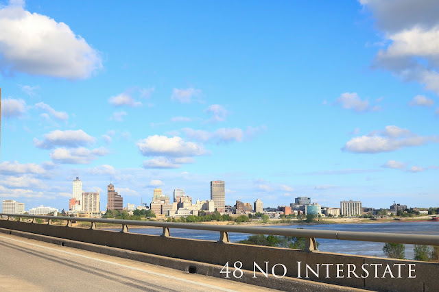
Crossing the Mighty Mississippi into Memphis from Arkansas, look to the right to see the city skyline or to the left to see a big glass pyramid welcoming you to the city.
A walk through historic downtown Fredericksburg, Virginia makes you feel like you have stepped back in time if you can ignore the modern cars lining the street.
Not the typical scene you think of when you think of our nation's capital city, is it? Everyone has seen a picture of the White House or Washington Monument, and this city scene seemed like a more appropriate representation of passing through the city on a road trip.
This little red 19th century one room schoolhouse in Maryland brightened up an otherwise wet and dreary day.
Behind the iron gates sits a marker from the Mason-Dixon line in present-day Delaware (at the time, the land was part of the Pennsylvania colony). First measured by local surveyors in about 1760 and marked by two small stones, a larger stone was put in place after Charles Mason and Jeremiah Dixon made their measurements in 1764 to solve a land dispute and establish the border between Maryland and Pennysylvania.
The cupola of Independence Hall peeks over the roof line of the Old City Hall building in the heart of Historic Philadelphia. Roaming through the cobblestone streets with no particular destination recalling as much of the history we learned in school as we could was a nice break from the road.
The view from our Brooklyn hotel (along with a larger room and more convenient parking) made the long subway rides into Manhattan worth it.
About 60 miles north of the city, the United States Military Academy at West Point boasts some amazing architecture including the protestant Cadet Chapel, nestled in the mountains overlooking the campus and Hudson River far below.
Quaint coastal scenes like this one in Rhode Island were common as we drove along US 1 between NYC and Maine.
Built in the 1600s, the home of Paul Revere is the oldest building in downtown Boston. In the 1800s, it became unrecognizeable as a result of renovations to turn it into a boardinghouse and later a variety of different shops. It was restored in the early 1900s to the condition it would have appeared when Paul made his famous ride in 1775 and has been open to tourists for over a hundred years!
It turned cold on us as we traveled US 1 through New England; for several days, it was as chilly and unpleasant (or maybe more so) as it looks in this photo. Though it felt pretty miserable, it made for a uniquely beautiful drive through these coastal towns along an angry ocean under a veil of fog.
There's something about West Quoddy Head Light, the Easternmost lighthouse in the US, that I just love to look at. The red and white tower rising out of the green grass, set against the backdrop of blue-gray water is very appealing to my eyes. It was super cold and miserable in person, though.
I know if you live in the Northeast, this sign near the Maine-New Hampshire border is not that unique. But it was enough to make these two southerners stop for a photo. We never did see any moose, though.
We saw very few of the many covered bridges in Vermont, but this particular stretch near Northfield had three in a row, giving us a pretty big bang for our buck!
We crossed the border (the Canadian border guard definitely thought we were suspicious characters when we told him about our road trip in response to his questions about why we were coming to Canada and why we were driving so far from home; he seemed to think we were nuts for doing it!) for a quick international stop. Here, the American falls provide a dazzling backdrop for a garden full of stunning Canadian tulips.
Prior to our trip, it for some reason never occurred to me that there would be lighthouses near the Great Lakes. The Oswego Harbor West Pierhead light in Oswego, New York was just one of many that we passed on the Great Lakes Seaway Trail.
I love seeing barns and farmhouses scattered in the middle of fields as we drive through farmland, like this one celebrating the state's bicentennial near the Ohio-Michigan border.
Mackinac Island was another place I knew nothing about until we visited it. The absence of cars doesn't mean you can just walk down the middle of the street, though; carriages and bicycles replace them in large numbers, so stick to the sidewalk!
During our tour of Lambeau Field, I got separated from our group when I stepped into the restroom. As a result, I missed the part of the tour that takes visitors through the tunnel and on to the Packers' field. When I finally found the group again the tour was basically over, but the tour guide kindly took us on a private mini-tour of the field. We learned that the guide and his brother had gotten tickets in the kids' section behind one of the end zones in the 70s or 80s. When the section was later converted into a regular section, they managed to keep hold of them and still have the same tickets today.
Illinois gets two pictures of very different scenes. The first is a city and lake view from the top of the Willis (or Sears, if old habits die as hard for you as they do for me) Tower...
...the second is a 1.4 mile section of brick road on Route 66 laid in 1931 in Auburn, IL, about 200 miles Southwest of Chicago.
Joplin sits on Route 66 in southwest Missouri. Completely by coincidence, we drove through Joplin on the fifth anniversary of the EF5 tornado that blew through on Sunday, May 22, 2011, taking with it the lives of 161 people and destroying areas up to a mile wide. It was surreal to drive through and pick out these areas, easily noticed as a result of sudden stretches of new construction or steps going from the sidewalk up to nowhere, on lots where houses had not been rebuilt. For the fifth anniversary, the town held a monthlong celebration, ending with a marathon and a remembrance ceremony the weekend we passed through.
I'm glad to know that they've paid their bills, but we'd rather not stay at the Rest Haven Motel in Afton, OK, near the Kansas-Oklahoma border on Route 66.
Since they're so high up in the air, it's hard to grasp how large wind turbines actually are. Compare the size of a turbine blade lying on the ground to the telephone poles in the photo below, taken as we filled up the gas tank somewhere in western Kansas. Hundreds of blades just like this one were laid end to end at this massive facility.
Along the Colorado River between Denver and Steamboat Springs, CO, US 40 parallels the tracks that carry Amtrak's California Zephyr from Chicago to San Francisco. What a way to see the country!
Nearly as tall as the Empire State Building (1,250 feet not counting its antenna), Utah's tallest man-made structure is the Garfield Smelter (1,215 feet) at the Rio Tinto mining facility, whose annual production includes tons of copper, thousands of ounces of gold, and millions of ounces of silver.
To reach the beach from our cliff-top hotel in Lincoln City, Oregon, we had to take 112 steps down - and back up. A short stroll on the chilly beach was the most time these east coasters have spent in such close proximity to the Pacific.
Montana was one of those states that made it incredibly difficult to pick just one picture for this post. This one from our hike along the river in Glacier National Park was the winner.
Prior to the two days we spent in Yellowstone, I knew nothing about it other than the presence of Old Faithful and the fact that it was the first national park. There were hundreds of pictures of geysers, colorful springs, and wildlife to choose from, but I kept coming back to this one of the beginning of the sunset over a green valley as we left the park to head east across Wyoming.
Ignorance can certainly be bliss. The fact that we were unaware of exactly what the Badlands are made them such a surprise to us. An even better surprise was coming across this guy sitting peacefully on a rock, looking out at the vast landscape before him.
While I don't think I want to visit Minneapolis between October and April because I don't think I could handle the cold, it was beautiful and pleasant for an early June trip. Before leaving town, we took a walk along a short stretch of the Chain of Lakes and wished we had time to rent a kayak, too.
We're reinforcing the stereotype of Iowa as being full of farms and cornfields, but I'm a sucker for sunsets and flat stretches of farmland and couldn't resist.
Little did we know that when I walked into an alleyway in Noblesville, Indiana to get a picture of its amazing city hall building that nearly a year later, we would be back in that same town for an extended period for Nick's work eating dinner al fresco at an Italian restaurant in that exact alley.
Driving through the lush, green horse country near Lexington, we made one stop on the Kentucky Bourbon Trail at Woodford Reserve. The tour was fantastic, but it didn't make me like bourbon any better.
We accomplished our task in West Virginia, state number 48! The only thing we did there was get out of the car to document said accomplishment with a selfie, though.
We finished off our trip with a weekend in the Outer Banks, but even though it was mid-June, it was NOT pleasant beach weather! We arrived at the Bodie Island Light Station too late in the day to get tickets for the self-guided climb so enjoyed a scenic walk around its grounds instead.
We returned home to South Carolina with a lifetime full of experiences and a long list of places we'd like to visit again slower and more intentionally. It felt strange to walk into our house, and after three months of not cooking, it took me a week or so to get back into the swing of things. It was a fun and amazing experience, and even though we missed a few items on the list of places we wanted to stop, we're so grateful we were able to take the trip and wouldn't change a thing!
Thanks for following along with us on this trip down memory lane. Check out the next post in this series with answers to commonly asked questions about taking an extended back roads road trip!
Thanks for visiting, and check out these groups for more travel inspiration!
If you liked this article or found the information to be helpful, let us know! We appreciate your comments, pins, shares, tweets, and likes!















Just found your blog...what an amazing trip! I'm going to have to spend some time looking around..thanks for sharing!
ReplyDeleteThanks for stopping by! Hope you enjoy reading some of our other stuff!
DeleteThis is so amazing! Pumped to read more about your trip. I think a lot of us who live in the US would like to do an epic road trip in one way or another. I have talked to a lot of people who want to drive the entire length of the country at least once. I would like to do that too. Thanks for providing some real inspiration! #wkendtravelinspiration
ReplyDeleteThanks, Ruth! It still seems surreal to both of us that we did it. Hope you're able to hit the road sooner than later for your own cross-country trip!
DeleteOh my goodness! What an amazing trip! Thank you for sharing it with us!
ReplyDeleteThanks for reading, April!
DeleteThat was an awesome trip. So many places (and so many great photos). I can't wait to see what you have in store over the next 2 weeks.
ReplyDeleteThanks, Rhonda! :-)
DeleteFantastic! I really enjoyed the personal detail of each pic and you've really made me want to do this myself. You really had an amazing experience thats for sure! :-)
ReplyDeleteGlad you liked it. This was a fun way to relive the trip a little, too.
DeleteWow, what an amazing journey! I'm looking forward to more! Thanks for linking up! #wkendtravelinspiration
ReplyDeleteThanks for reading, Jim!
DeleteI really enjoyed this overall retrospective of your trip. I've been reading your blog posts about the different legs, and it was fun to see how everything linked together. I'd love to do this type of roadtrip.
ReplyDeleteHi, Michele - My hope was that this post would do just that. I'm glad you enjoyed it, and thanks for reading!
Deletewow! This is just incredible! What an amazing adventure, and such lovely photos! It must have been a real challenge choosing just one for each place! #theweeklypostcard
ReplyDeleteIt was so hard!! My original plan was to do one photo for each state, but you'll notice some areas got more love than others... :-) Thanks for stopping by!
DeleteI want to do this trip again! This was such a beautiful post, and your pictures were amazing. I think my favorites (other than Oregon of course since it's our new home) were the terrain and mountains of New Mexico and Montana. They are such adventurous destinations! I'm happy to hear that you were only attacked by one cactus on the trip <3
ReplyDeleteIt was a small one, too, fortunately, but it did take some effort to unstick the spines out of my shoe.
DeleteThe Southwest was an amazing surprise to us; even though we had seen photos of some areas, it was just breathtaking in person. Oregon/Washington is a place we want to return to someday!
This is such a beautiful way of documenting! I especially loved seeing the red rocks of the Navajo, barns and farmhouses scattered in the middle of fields through your eyes.
ReplyDelete:-) Thanks, Shruti!
DeleteWow, truly the trip of a lifetime. Beautiful photos!
ReplyDeleteIt really was. I suppose now that we've done it, we could hang up our traveling hats and call it a day, but that doesn't seem likely! :-) Thank you!
DeleteWow what a trip! How are you going to top that?! I still have so many states I need to visit. #TheWeeklyPostcard
ReplyDeleteGood question! We probably won't! We'll see what the future holds, though. It does make for a kind of anticlimactic 'US States we have visited' map. ;-)
DeleteArizona is my dream. The best landscapers i have ever seen.
ReplyDeleteI agree; it's a really amazing place!
DeleteWow what an adventure you had. Bummer about running out of gas. My favorite is the photo of Horseshoe Bend. Great photos and thanks for sharing :-) #feetdotravel
ReplyDeleteIt makes a good story, though! Thanks for stopping by!
DeleteWow, that must be an epic trip. Love your photos!
ReplyDeleteThank you!
DeleteI can't believe how much ground you guys covered in 80 days! I'm planning 3-4 months on the road, with only about 10 states and I'm still having to pass up so much!
ReplyDelete#TheWeeklyPostcard
So much to see in so little time! You will still be able to see lots of things and visit lots of places within those 10 states. Enjoy!!
DeleteI've made a similar roadtrip before - but I was driving a loaded-down box truck full of junk at the time, so it wasn't nearly as awesome a time as it looks like you had! Great photos!
ReplyDeleteThanks for stopping by, Jeff. I guess the silver lining of driving a loaded down truck is that the scenery would go by a little more slowly. :-)
Delete