
Base Camp
Flagstaff, AZ
Flagstaff, AZ
One day round trip Flagstaff to The Grand Canyon.
One day round trip Flagstaff to Sedona, AZ.
The Route to The Grand Canyon
Hwy 89 to Sunset Crater National Monument > Hwy 89 to Cameron > Hwy 64 to The Grand Canyon

In addition to having a fun downtown area, Flagstaff sits in a beautiful part of the country. We arrived to a glowing sunset and woke the next morning to a view of the snow-capped San Francisco peaks (no, not in San Francisco) in the distance.


From Flagstaff, it is about a 30 minute ride to the Sunset Crater National Monument. The most prominent extinct volcanic mountain in this park is Sunset Peak, named by John Wesley Powell who "discovered" it in 1887. It looks like a sunburned black mountain, as the black volcanic ash has a slightly reddish tint.

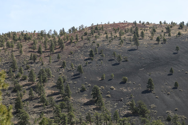
The earth around this eerie peak is scarred and marred by the trauma of ancient volcanic eruptions.

From here, traveling North on Hwy 89 over Gray Mountain through the Hopi Indian lands, the views from the road are ruggedly beautiful. This is a very scenic prelude to the main attraction you are traveling toward.


*Heading over the summit of Gray Mountain toward the Colorado River-carved valley


Soon after tuning onto Hwy 64, you arrive at the south rim of the Grand Canyon.


What pictures, movies, billboards, descriptions, and even the name "Grand" can't capture is the vastness of this Colorado River Canyon. The erosive power of wind and weather are on full mind-boggling display here.
At its widest point, the canyon is over 18 miles wide, and in many places it is more than 1 mile deep. Put another way, the island of Manhattan (north to south) could stretch from one rim to the other with room to spare, and three Empire State Buildings could be stacked on top of one another from the bottom without reaching the top.


The Grand Canyon, stretching over 250 miles long, is large and diverse enough that each new viewpoint on the canyon reveals distinctly unique scenery.


 *A glimpse of the natural chisel that carved this masterpiece
 *My sister's novel, Behind My Eyes, fits in nicely with the scenery
On the eastern portion of the south rim of the Grand Canyon, you are near the site of the 1956 collision of two commercial airliners. The mid-air collision caused both planes to crash into the canyon, killing all 128 passengers aboard both planes. This tragedy played a significant role in the modern air-traffic-control monitoring system that was put in place soon after.


After a day at the Grand Canyon, take Hwy 64 to Hwy 180 back to Flagstaff, AZ.
The Route to Sedona, AZ
 *The smoke was so thick that the surrounding light reminded me of the subdued daylight during a solar eclipse.
As we began to emerge from the woods, we saw some natural wonders that definitely did not look like anything we had ever seen in Tennessee.

 *"Flintstones, meet the Flintstones, they're the modern stone age family"...

Good Morning America, Guidebook America and TripAdvisor, among others, call Sedona "the most beautiful place in America." It is hard to argue with that.


We took a hike up Bell Rock to watch the sunset. As the sun went below the horizon, the red rocks seemed to glow until the light went out completely.


From Sedona, it is a short ride back up Hwy 89 Alt to Flagstaff, AZ. This, I promise, will be one of the few instances of back-tracking on this trip.
Stay tuned as we next travel over the London Bridge (yes, the real one! Will explain later) and into California; then through the Mojave Desert, Joshua Tree National Park, & Palm Springs to Los Angeles, CA.


In addition to having a fun downtown area, Flagstaff sits in a beautiful part of the country. We arrived to a glowing sunset and woke the next morning to a view of the snow-capped San Francisco peaks (no, not in San Francisco) in the distance.


From Flagstaff, it is about a 30 minute ride to the Sunset Crater National Monument. The most prominent extinct volcanic mountain in this park is Sunset Peak, named by John Wesley Powell who "discovered" it in 1887. It looks like a sunburned black mountain, as the black volcanic ash has a slightly reddish tint.


The earth around this eerie peak is scarred and marred by the trauma of ancient volcanic eruptions.

From here, traveling North on Hwy 89 over Gray Mountain through the Hopi Indian lands, the views from the road are ruggedly beautiful. This is a very scenic prelude to the main attraction you are traveling toward.


*Heading over the summit of Gray Mountain toward the Colorado River-carved valley


Soon after tuning onto Hwy 64, you arrive at the south rim of the Grand Canyon.


What pictures, movies, billboards, descriptions, and even the name "Grand" can't capture is the vastness of this Colorado River Canyon. The erosive power of wind and weather are on full mind-boggling display here.
At its widest point, the canyon is over 18 miles wide, and in many places it is more than 1 mile deep. Put another way, the island of Manhattan (north to south) could stretch from one rim to the other with room to spare, and three Empire State Buildings could be stacked on top of one another from the bottom without reaching the top.


On the eastern portion of the south rim of the Grand Canyon, you are near the site of the 1956 collision of two commercial airliners. The mid-air collision caused both planes to crash into the canyon, killing all 128 passengers aboard both planes. This tragedy played a significant role in the modern air-traffic-control monitoring system that was put in place soon after.


After a day at the Grand Canyon, take Hwy 64 to Hwy 180 back to Flagstaff, AZ.
The Route to Sedona, AZ
Hwy 89 Alt takes you straight there (& back)!

The road from Flagstaff to Sedona follows a forested path along a creek in a valley, with steep mountainous slopes guarding the sides. This reminded us more of Tennesee than what we had seen of Arizona. Along one stretch of road, we passed through a controlled burn of the surrounding woods.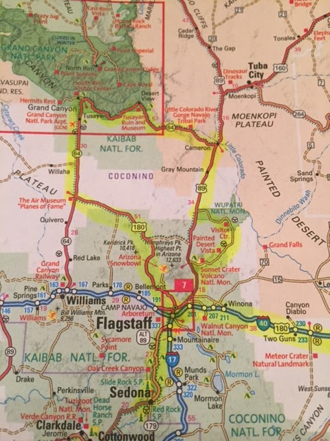

As we began to emerge from the woods, we saw some natural wonders that definitely did not look like anything we had ever seen in Tennessee.


Good Morning America, Guidebook America and TripAdvisor, among others, call Sedona "the most beautiful place in America." It is hard to argue with that.


We took a hike up Bell Rock to watch the sunset. As the sun went below the horizon, the red rocks seemed to glow until the light went out completely.


Stay tuned as we next travel over the London Bridge (yes, the real one! Will explain later) and into California; then through the Mojave Desert, Joshua Tree National Park, & Palm Springs to Los Angeles, CA.


Great. Makes me want to load up and go west .......
ReplyDelete